Monitoring Reforestation efforts Using Deep learning
Background
The Kieni Forest in Kiambu County, Kenya, plays a vital role in the region's ecological health. It provides habitat for diverse wildlife, regulates water resources, and helps combat climate change. However, deforestation and degradation have significantly impacted the forest cover. Reforestation efforts are crucial to restoring the Kieni Forest and its ecological benefits. This project aims to develop a robust and efficient method for forest monitoring in Kieni Forest using Deep Learning techniques.
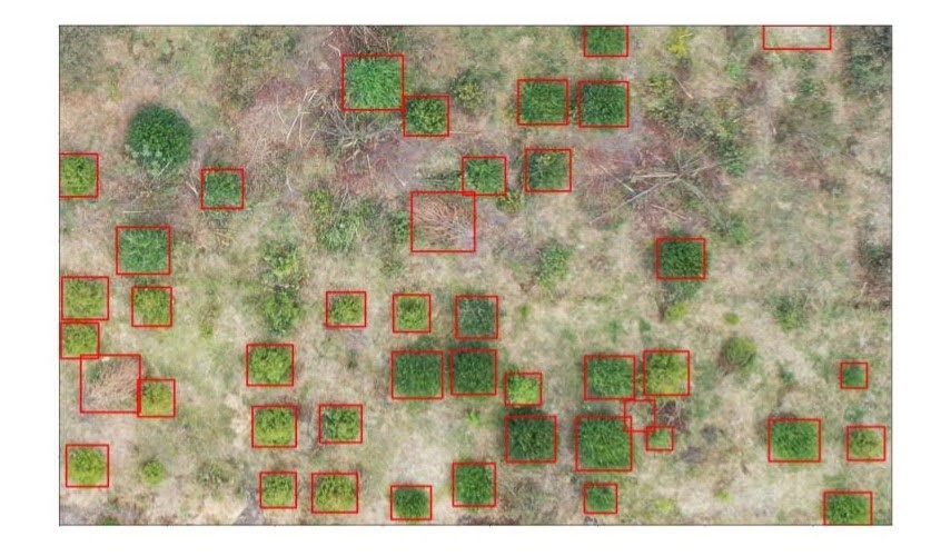
One way of conducting Forest monitoring is through tree crown detection using DeepForest, a pre-trained model from Weecology. Accurate tree crown detection will support reforestation efforts in several ways:
- Identify Existing Trees: By automatically detecting existing tree crowns, this project can create a baseline assessment of the current forest cover. This information is valuable for planning and prioritising reforestation areas.
- Monitor Progress: Repeated application of the tree crown detection model can track the success of reforestation initiatives. The model can quantify the increase in tree cover over time, allowing for informed adjustments to reforestation strategies.
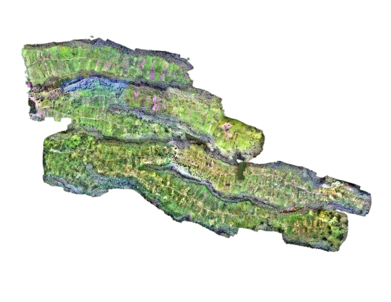
Our data collection exercises have resulted in drone images taken from a reforested section of the
forest to
provide the data for forest monitoring. Drones capture multiple images in an RGB (Red, Green, Blue)
format,
which represents the natural colour we see things through. This makes it easy to see the tree crowns
from the various images.
There are efforts to monitor the reforestation in Kieni by starting out with data collection, which
includes the collection of tree parameter details such as tree height, basal diameter, crown diameter
and tree species identification.
We also employed DSAIL's TreeVision, a low-computation software tool that combines stereoscopic vision
and deep learning to automatically estimate tree biophysical parameters, such as diameters at breast
height, tree heights, and crown diameters.
The TreeVision software is used together with stereoscopic vision to capture tree images and create a 3D
map of the scene.
This is all in an effort to monitor the growth of trees in the forest.
Accomplishments
- Tree crown detection has been done on a section of the forest using drone images. The model's performance has been evaluated using metrics such as F1-score, recall, and precision, which provide valuable insights into the model's accuracy and help identify areas for improvement. Tree crown diameters have been calculated and compared to the ground truth data collected in the field, which showed the possibility of using deep learning in monitoring the reforested sections of Kieni forest. It was a privilege to have an abstract concerning the research on Using Drone Imagery and Deep Learning to Monitor a Reforested Stand in Kenya accepted for the AGU Conference 2024 and 2025. The abstract can be accessed below. AGU24
- The collection from our fieldwork has yielded a carefully curated dataset, Miti360 is a comprehensive, high-resolution, multi-modal dataset created to support machine learning research on African forestry, specifically addressing the lack of ML-ready datasets for tree monitoring in Kenya. It integrates diverse data collected from a 770 ha reforested stand in the Kieni Forest, including high-resolution drone orthophotos and tiles, tree crown annotations (COCO-JSON), species labels (CSV and shapefile), ground measurements of individual trees, terrestrial and stereo imagery with corresponding masks, and long-term daily weather observations from 40 stations. This rich combination of aerial, terrestrial, numerical, and environmental data is designed to enable tasks such as species identification, biophysical estimation (like tree height and biomass), and predictive modelling of tree growth and response to weather conditions. The dataset was presented during the latest AGU in New Orleans [AGU25]
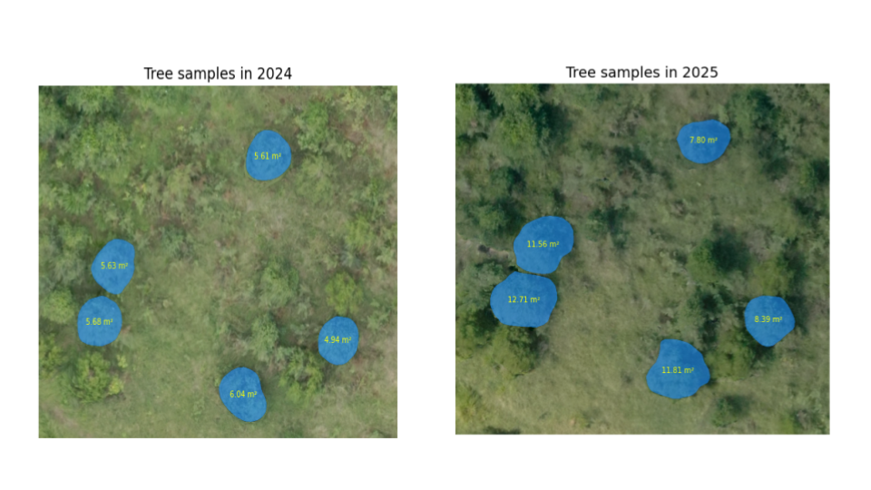
- Developed and implemented a complete processing pipeline for mask generation using the Segment Anything Model (SAM). The pipeline automates the segmentation of drone imagery into object masks, enabling efficient large-scale forest monitoring. Initial tests have been conducted on multiple image tiles to assess the model’s segmentation accuracy and consistency across different seasons. The successful results demonstrate the pipeline’s capability to support subsequent analysis tasks such as area estimation.
Next Steps
For our next steps, we aim to:
Fine Tuning the model: Further training and adjustments to the
DeepForest model can be conducted to enhance its accuracy and performance. This might involve
incorporating additional training data, exploring different hyperparameter configurations, or trying
alternative deep learning architectures.
Scaling up: This is probably a futuristic step, to
apply the model to larger regions within the Kieni Forest, potentially using multiple drone images to
cover extensive areas. This requires strategies for efficient image processing and model application
across larger datasets.